


Cold-Water Climate Shield
Populations of many cold-water aquatic species are likely to decline this century with climate change, but declines will vary spatially. Some populations will be able to persist even under extreme climate change scenarios. Especially cold habitats could provide important refugia from both future environmental change and invasions by non-native species that prefer warmer waters.
The Climate Shield website hosts geospatial data and related information on specific locations of cold-water refuge streams for native cutthroat trout and bull trout across the northwestern United States. Forecasts about the locations of refugia could enable the protection of key watersheds, be used to rally support among multiple stakeholders, and provide a foundation for planning climate-smart conservation networks that improve the odds of preserving native trout populations through the 21st century. These data are available for three scenarios: historical (1970–1999), mid-century (2030–2059), and end-of-century (2070–2099).
Climate Shield was inspired by the landscapes of the Rocky Mountains and people everywhere that are working to preserve native trout. The Northern Rockies Adaptation Partnership provided a valuable forum that accelerated this work. The Great Northern and North Pacific Landscape Conservation Cooperatives generously funded the NorWeST project, which serves as the foundation for Climate Shield.
- Overview
- Trout Distribution Monitoring
- Fish Data Sources
- Climate Shield Download Units
- Posters of Rangewide Distribution
- Revised Bull Trout Climate Shield Model
- Dynamic Online Map Viewers and GIS Data
- Resources
While a major goal of this project is to provide climate vulnerability and native trout refuge information to land managers and policymakers, another goal is to provide open access to the information through a common digital database and project website so that it can be accessed and used by anyone concerned about native trout in the region. The techniques and technology used to build Climate Shield are broadly applicable to other species and geographic areas and have shifted the paradigm of how natural resources research can be conducted.
“The high-resolution digital information from the study is the perfect complement to local knowledge, because it provides strategic maps that allow managers to put each stream in a broader context and make ‘apples to apples’ comparisons across landscapes in the northwest,” said RMRS investigator Dan Isaak.
The Climate Shield habitat occupancy models provide stream-specific probabilistic predictions about the occurrence of juvenile Bull Trout and Cutthroat Trout throughout the northwestern U.S. Those predictions can be used as prior probabilities to design efficient population monitoring programs and distributional assessments. For example, the electrofishing site detection efficiency estimates derived in Appendix 2 of the Climate Shield manuscript can be used with the spatial information at this website to plan where and how much sampling is necessary to detect either native trout species within a cold-water habitat as described in Peterson and Dunham (2003) and Isaak et al. (2009). The prior probabilities and spatial information can also be used with other sampling techniques like environmental DNA that is being rapidly adopted because of its low cost and high sensitivity for detecting species (Wilcox et al. 2013, 2014; National Genomics Center for Wildlife and Fish Conservation). As more samples are collected in future years, the precision of the Climate Shield models may be increased or new models developed for other aquatic species of concern.

The original Climate Shield Cutthroat Trout and Bull Trout models published by Isaak et al. (2015) were developed from electrofishing fish surveys conducted at >4,500 locations in >500 natal streams patches across Montana, Idaho, and Oregon as described in the peer-reviewed studies and agency reports listed below.
A revised Climate Shield bull trout model was published by Isaak et al. (2022) based on an expanded data set of 9,857 surveys in 991 stream patches that included eDNA surveys from the Rangewide Bull Trout eDNA Project (Young et al. 2017). This data set with the covariate values used in model fitting and selection is available here in Excel and ArcGIS file formats. Please refer to this ReadMe document for descriptions of the covariates and the Isaak et al. (2022) publication for additional details.
Special thanks to the many biologists with the National Forest system for providing data from their fish monitoring programs and Leslie Nyce with Montana Fish, Wildlife and Parks for assistance with accessing information through the MFISH database.
Climate Shield Download Unit
The Climate Shield models developed by Isaak et al. (2015) provide stream-specific rangewide probabilistic predictions about the occurrence of juvenile Bull Trout and Cutthroat Trout under different scenarios of climate change and Brook Trout invasions. That information is available here as easy-to-use digital maps (.pdf files) and ArcGIS shapefiles for all streams within the historical ranges of these two native trout species across the western U.S. The geographic areas match the NorWeST production units because those stream temperature scenarios are integral to Climate Shield.
The climate scenarios used in this project represent baseline (1980s), moderate (2040s), and extreme (2080s) climate change conditions and were chosen because they bracket what might be considered a “pristine” historical condition and “worst-case” end-of-century conditions.
The full dataset is available for download from the FSGeodata Clearinghouse.
Data are added as basins are completed and are subject to periodic revision - General Metadata for shapefiles | Climate Shield Download Units Polygon Shapefile
Note: Reaches coded as “intermittent” in the NHD streams used to develop these maps were not deleted to provide users with maximum flexibility in applying this information. But those reaches can be highlighted or deleted from shapefiles below simply by linking then to the NHD stream dataset.
Citation
Isaak, D., M. Young, D. Nagel, D. Horan, M. Groce, and S. Parkes. 2017. Climate Shield bull trout and cutthroat trout population occurrence scenarios for the western U.S. Rocky Mountain Research Station, U.S. Forest Service Data Archive, Fort Collins, CO. DOI: pending.
Climate ScenariosN/A = area is outside the historical range of the species
| ||||||||||||
Baseline (1980s) | Moderate (2040s) | Extreme (2080s) | ||||||||||
Bull Trout | Cutthroat Trout | Bull Trout | Cutthroat Trout | Bull Trout | Cutthroat Trout | |||||||
0% Brook | 50% Brook | 0% Brook | 50% Brook | 0% Brook | 50% Brook | 0% Brook | 50% Brook | 0% Brook | 50% Brook | 0% Brook | 50% Brook | |
| New Mexico | N/A | N/A | N/A | N/A | N/A | N/A | ||||||
N/A | N/A | .shp | N/A | .shp | ||||||||
| Colorado | N/A | N/A | N/A | N/A | N/A | N/A | ||||||
N/A | N/A | N/A | ||||||||||
| Clearwater | .pdf | |||||||||||
| Mid Columbia | ||||||||||||
| Mid Snake | N/A | N/A | N/A | N/A | N/A | N/A | ||||||
N/A | N/A | N/A | ||||||||||
| Missouri Headwaters | N/A | N/A | N/A | N/A | N/A | N/A | ||||||
N/A | N/A | N/A | ||||||||||
| Oregon Coast | ||||||||||||
| Salmon | ||||||||||||
| South-Central Oregon | N/A | N/A | ||||||||||
N/A | ||||||||||||
| SpoKoot | ||||||||||||
| Snake-Bear | ||||||||||||
| Upper Columbia- Yakima | ||||||||||||
| Washington Coast | ||||||||||||
| Upper Missouri-Marias | ||||||||||||
| Upper Yellowstone- Bighorn | ||||||||||||
| Upper Green-North Platte | N/A | N/A | N/A | N/A | N/A | N/A | ||||||
N/A | N/A | N/A | ||||||||||
| Lahontan | N/A | N/A | N/A | N/A | N/A | N/A | ||||||
N/A | N/A | N/A | ||||||||||
| Utah | N/A | N/A | N/A | N/A | N/A | N/A | ||||||
N/A | N/A | N/A | ||||||||||
Posters of Rangewide Distribution
| Species | Climate period | 0% Brook Trout | 50% Brook Trout |
|---|---|---|---|
| Bull trout | 1980s | ||
| 2040s | |||
| 2080s | |||
Cutthroat trout updated June 2015 | 1980s | ||
| 2040s | |||
| 2080s | |||
Revised Bull Trout Climate Shield Model
Isaak et al. (2022) published a revised Climate Shield model for juvenile bull trout that provides stream-specific probabilistic predictions about occurrence within 991 natal habitat patches across Montana, Idaho, and eastern Oregon. The model is more accurate than the original Climate Shield model and was used in 16 scenarios to assess the effects of habitat restoration and brook trout removals on improving population resilience under three climatic conditions (baseline, moderate change, and extreme change). That information is available from the table below as digital maps (.pdf files) and ArcGIS shapefiles. Please refer to this ReadMe document for descriptions of the scenarios and the Isaak et al. (2022) publication for additional details.
| Climatic Condition | Scenarios | |
| ||
| Baseline Conditions | Scenarios 1-8 | |
| Moderate climate change | Scenarios 9-12 | |
| Extreme climate change | Scenario 13 | Scenarios 13-16 |
| Covariate Shapefile available for download | Bull Trout Natal Habitat Patches | |
Dynamic Online Map Viewers and GIS Data
Stream Temperature and Native Trout
USFS Office of Sustainability and Climate Story Map on Stream Temperature and Native Trout, including Stream Temperature, Bull Trout Habitat, and Cutthroat Trout Habitat.
Climate Shield Cold-Water Refuge Streams For Native Trout
Boise Spatial Streams Group
These datasets can be viewed in ArcGIS Online or in the interactive Climate Shield viewer; they are also available from the FSGeodata Clearinghouse, or for individual processing units see the table below.
Note that because the distribution of Brook Trout is poorly known in many areas, making precise predictions about their effects within each stream is impossible so only two scenarios are provided in the digital map .pdf files (0% and 50%). However, the Climate Shield predictive models can be used to assess a broad range of Brook Trout invasions so ‘look-up’ tables that provide stream-specific native trout occurrence probabilities for Brook Trout invasions of: 0%, 25%, 50%, 75%, and 100% are also provided. Those tables are linked to the ArcGIS shapefiles to enable dynamic spatial queries where local information is available about Brook Trout densities. More details are included in the Climate Shield manuscript published in Global Change Biology.
Documents
-
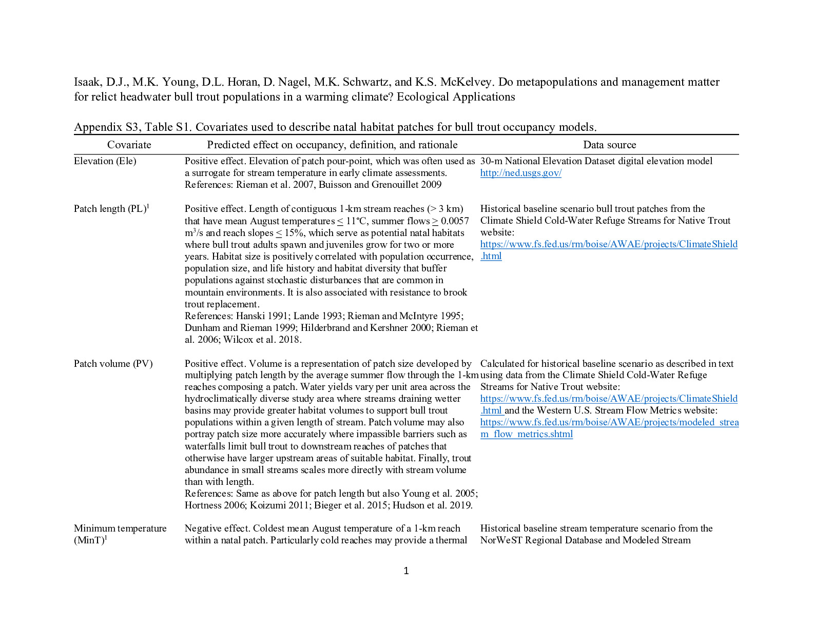 https://research.fs.usda.gov/sites/default/files/2023-05/rmrs-appendix_s3.pdfFile Type: pdf
File Size: 314KB -
 https://research.fs.usda.gov/sites/default/files/2023-05/rmrs-the_cold-water_climate_shield_delineating_refugia_for_preserving_native_trout_through_the_21st_century.pdfFile Type: pdf
File Size: 3.36MB -
 https://research.fs.usda.gov/sites/default/files/2023-05/coldwater_as_a_climate_shield_to_preserve_native_trout_in_the_21st_century.pdfFile Type: pdf
File Size: 10.84MB -
 https://research.fs.usda.gov/sites/default/files/2023-05/rmrs-the_rapid_range-wide_inventory_of_bull_trout_a_crowd-sourced_edna-based_approach_with_application_to_many_aquatic_species.pdfFile Type: pdf
File Size: 4.10MB -
 https://research.fs.usda.gov/sites/default/files/2023-05/rmrs-the_cold-water_climate_shield_delineating_long-term_climate_refugia_for_cutthroat_trout.pdfFile Type: pdf
File Size: 7.38MB -
 https://research.fs.usda.gov/sites/default/files/2023-05/rmrs-this_centurys_bull_trout_forecast_partly_sunny_with_scattered_rain_showers.pdfFile Type: pdf
File Size: 5.73MB -
 https://research.fs.usda.gov/sites/default/files/2023-05/rmrs-building_a_crowd-sourced_climate_shield_aquatic_ednatlas_to_protect_biodiversity_in_the_american_west.pdfFile Type: pdf
File Size: 5.92MB -
 https://research.fs.usda.gov/sites/default/files/2023-05/rmrs-whither_the_hybrid_swarm.pdfFile Type: pdf
File Size: 5.94MB -
 https://research.fs.usda.gov/sites/default/files/2023-05/rmrs-climate_shield_cold-water_refuge_streams_for_bull_trout.pdfFile Type: pdf
File Size: 5.20MB -
 https://research.fs.usda.gov/sites/default/files/2023-05/turning_conservation_on_its_head.pdfFile Type: pdf
File Size: 691KB -
 https://research.fs.usda.gov/sites/default/files/2023-05/rmrs-isaak_et_al_2015_the_cold_water_climate_shield_appendix_s1.pdfFile Type: pdf
File Size: 1.79MB -
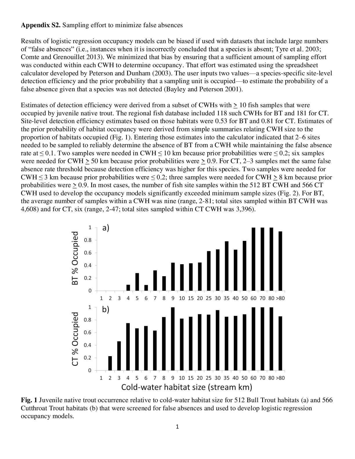 https://research.fs.usda.gov/sites/default/files/2023-06/rmrs-appendix_s2._sampling_effort_to_minimize_false_absences.pdfFile Type: pdf
File Size: 478KB -
 https://research.fs.usda.gov/sites/default/files/2023-06/the_status_of_fishes_on_the_challis_ranger_district.pdfFile Type: pdf
File Size: 6.32MB -
 https://research.fs.usda.gov/sites/default/files/2023-06/rmrs-2010_sawtooth_bull_trout_management_indicator_species_monitoring_report.pdfFile Type: pdf
File Size: 827KB -
 https://research.fs.usda.gov/sites/default/files/2023-06/rmrs-2011_sawtooth_bull_trout_management_indicator_species_monitoring_report.pdfFile Type: pdf
File Size: 779KB -
 https://research.fs.usda.gov/sites/default/files/2023-06/rmrs-2012_sawtooth_bull_trout_management_indicator_species_monitoring_report.pdfFile Type: pdf
File Size: 1.51MB -
 https://research.fs.usda.gov/sites/default/files/2023-06/rmrs-the_status_of_fishes_on_the_yankee_fork_ranger_district_salmon-challis_national_forest.pdfFile Type: pdf
File Size: 2.76MB -
 https://research.fs.usda.gov/sites/default/files/2023-06/rmrs-the_status_of_fishes_on_the_middle_fork_ranger_district_salmon-challis_national_forest_2002-2008.pdfFile Type: pdf
File Size: 7.58MB -
 https://research.fs.usda.gov/sites/default/files/2023-06/rmrs-boise_national_forest_aquatic_management_indicator_species_monitoring_report_2004.pdfFile Type: pdf
File Size: 1.06MB -
 https://research.fs.usda.gov/sites/default/files/2023-06/rmrs-boise_national_forest_aquatic_management_indicator_species_monitoring_report_2005.pdfFile Type: pdf
File Size: 962KB -
 https://research.fs.usda.gov/sites/default/files/2023-06/rmrs-boise_national_forest_aquatic_management_indicator_species_monitoring_report_2006.pdfFile Type: pdf
File Size: 988KB -
 https://research.fs.usda.gov/sites/default/files/2023-06/psw-boise_national_forest_aquatic_management_indicator_species_monitoring_report_2008.pdfFile Type: pdf
File Size: 973KB -
 https://research.fs.usda.gov/sites/default/files/2023-06/rmrs-sawtooth_aquatic_management_indicator_species_monitoring_report_2008.pdfFile Type: pdf
File Size: 475KB -
 https://research.fs.usda.gov/sites/default/files/2023-06/rmrs-boise_national_forest_aquatic_management_indicator_species_monitoring_report_2012.pdfFile Type: pdf
File Size: 904KB -
 https://research.fs.usda.gov/sites/default/files/2023-06/rmrs-boise_national_forest_aquatic_management_indicator_species_monitoring_report_2013.pdfFile Type: pdf
File Size: 944KB -
 https://research.fs.usda.gov/sites/default/files/2023-06/rmrs-sawtooth_national_forest_aquatic_management_indicator_species_monitoring_report_2005.pdfFile Type: pdf
File Size: 621KB -
 https://research.fs.usda.gov/sites/default/files/2023-06/rmrs-sawtooth_national_forest_aquatic_management_indicator_species_monitoring_report_2006.pdfFile Type: pdf
File Size: 644KB -
 https://research.fs.usda.gov/sites/default/files/2023-06/rmrs-sawtooth_national_forest_aquatic_management_indicator_species_monitoring_report_2007.pdfFile Type: pdf
File Size: 513KB -
 https://research.fs.usda.gov/sites/default/files/2023-06/rmrs-newmexico_1980scutthroattroutbk0.pdfFile Type: pdf
File Size: 5.83MB -
 https://research.fs.usda.gov/sites/default/files/2023-06/rmrs-newmexico_1980scutthroattroutbk50.pdfFile Type: pdf
File Size: 7.66MB -
 https://research.fs.usda.gov/sites/default/files/2023-06/rmrs-newmexico_2040scutthroattroutbk0.pdfFile Type: pdf
File Size: 7.61MB -
 https://research.fs.usda.gov/sites/default/files/2023-06/rmrs-newmexico_2040scutthroattroutbk50.pdfFile Type: pdf
File Size: 7.65MB -
 https://research.fs.usda.gov/sites/default/files/2023-06/rmrs-newmexico_2080scutthroattroutbk0.pdfFile Type: pdf
File Size: 7.61MB -
 https://research.fs.usda.gov/sites/default/files/2023-06/rmrs-newmexico_2080scutthroattroutbk50.pdfFile Type: pdf
File Size: 7.64MB -
 https://research.fs.usda.gov/sites/default/files/2023-06/rmrs-colorado_1980scutthroattroutbk0_reduced.pdfFile Type: pdf
File Size: 5.18MB -
 https://research.fs.usda.gov/sites/default/files/2023-06/rmrs-colorado_1980scutthroattroutbk50_reduced.pdfFile Type: pdf
File Size: 5.20MB -
 https://research.fs.usda.gov/sites/default/files/2023-06/rmrs-colorado_2040scutthroattroutbk0_reduced.pdfFile Type: pdf
File Size: 5.15MB -
 https://research.fs.usda.gov/sites/default/files/2023-06/rmrs-colorado_2040scutthroattroutbk50_reduced.pdfFile Type: pdf
File Size: 5.17MB -
 https://research.fs.usda.gov/sites/default/files/2023-06/rmrs-colorado_2080scutthroattroutbk0_reduced.pdfFile Type: pdf
File Size: 5.13MB -
 https://research.fs.usda.gov/sites/default/files/2023-06/rmrs-colorado_2080scutthroattroutbk50_reduced.pdfFile Type: pdf
File Size: 5.15MB -
 https://research.fs.usda.gov/sites/default/files/2023-06/rmrs-clearwater_1980sbulltroutbk0.compressed.pdfFile Type: pdf
File Size: 8.65MB -
 https://research.fs.usda.gov/sites/default/files/2023-06/rmrs-clearwater_1980sbulltroutbk50.compressed.pdfFile Type: pdf
File Size: 8.65MB -
 https://research.fs.usda.gov/sites/default/files/2023-06/rmrs-clearwater_1980scutthroatbk0.compressed.pdfFile Type: pdf
File Size: 8.76MB -
 https://research.fs.usda.gov/sites/default/files/2023-06/rmrs-clearwater_1980scutthroatbk50.compressed.pdfFile Type: pdf
File Size: 8.72MB -
 https://research.fs.usda.gov/sites/default/files/2023-06/rmrs-clearwater_2040sbulltroutbk50.compressed.pdfFile Type: pdf
File Size: 8.45MB -
 https://research.fs.usda.gov/sites/default/files/2023-06/rmrs-clearwater_2040scutthroatbk0.compressed.pdfFile Type: pdf
File Size: 8.58MB -
 https://research.fs.usda.gov/sites/default/files/2023-06/rmrs-clearwater_2040scutthroatbk50.compressed.pdfFile Type: pdf
File Size: 8.58MB -
 https://research.fs.usda.gov/sites/default/files/2023-06/rmrs-clearwater_2080sbulltroutbk0.compressed.pdfFile Type: pdf
File Size: 8.39MB -
 https://research.fs.usda.gov/sites/default/files/2023-06/rmrs-clearwater_2080sbulltroutbk50.compressed.pdfFile Type: pdf
File Size: 8.40MB -
 https://research.fs.usda.gov/sites/default/files/2023-06/rmrs-clearwater_2080scutthroatbk0.compressed.pdfFile Type: pdf
File Size: 8.48MB -
 https://research.fs.usda.gov/sites/default/files/2023-06/rmrs-clearwater_2080scutthroatbk50.compressed.pdfFile Type: pdf
File Size: 8.47MB -
 https://research.fs.usda.gov/sites/default/files/2023-06/rmrs-midcolumbia_1980sbulltroutbk0.compressed.pdfFile Type: pdf
File Size: 7.54MB -
 https://research.fs.usda.gov/sites/default/files/2023-06/rmrs-midcolumbia_1980sbulltroutbk50.compressed.pdfFile Type: pdf
File Size: 7.55MB -
 https://research.fs.usda.gov/sites/default/files/2023-06/rmrs-midcolumbia_1980scutthroatbk0.compressed.pdfFile Type: pdf
File Size: 7.44MB -
 https://research.fs.usda.gov/sites/default/files/2023-06/rmrs-midcolumbia_1980scutthroatbk50.compressed.pdfFile Type: pdf
File Size: 7.44MB -
 https://research.fs.usda.gov/sites/default/files/2023-06/rmrs-midcolumbia_2040sbulltroutbk0.compressed.pdfFile Type: pdf
File Size: 7.45MB -
 https://research.fs.usda.gov/sites/default/files/2023-06/rmrs-midcolumbia_2040sbulltroutbk50.compressed.pdfFile Type: pdf
File Size: 7.44MB -
 https://research.fs.usda.gov/sites/default/files/2023-06/rmrs-midcolumbia_2040scutthroatbk0.compressed.pdfFile Type: pdf
File Size: 7.40MB -
 https://research.fs.usda.gov/sites/default/files/2023-06/rmrs-midcolumbia_2040scutthroatbk50.compressed.pdfFile Type: pdf
File Size: 7.40MB -
 https://research.fs.usda.gov/sites/default/files/2023-06/rmrs-midcolumbia_2080sbulltroutbk0.compressed.pdfFile Type: pdf
File Size: 7.40MB -
 https://research.fs.usda.gov/sites/default/files/2023-06/rmrs-midcolumbia_2080sbulltroutbk50.compressed.pdfFile Type: pdf
File Size: 7.40MB -
 https://research.fs.usda.gov/sites/default/files/2023-06/rmrs-midcolumbia_2080scutthroatbk0.compressed.pdfFile Type: pdf
File Size: 7.38MB -
 https://research.fs.usda.gov/sites/default/files/2023-06/rmrs-midsnake_1980sbulltroutbk0.compressed.pdfFile Type: pdf
File Size: 8.26MB -
 https://research.fs.usda.gov/sites/default/files/2023-06/rmrs-midsnake_1980sbulltroutbk50.compressed.pdfFile Type: pdf
File Size: 8.27MB -
 https://research.fs.usda.gov/sites/default/files/2023-06/rmrs-midsnake_2040sbulltroutbk0.compressed.pdfFile Type: pdf
File Size: 8.20MB -
 https://research.fs.usda.gov/sites/default/files/2023-06/rmrs-midsnake_2040sbulltroutbk50.compressed.pdfFile Type: pdf
File Size: 8.20MB -
 https://research.fs.usda.gov/sites/default/files/2023-06/rmrs-midsnake_2080sbulltroutbk0.compressed.pdfFile Type: pdf
File Size: 8.17MB -
 https://research.fs.usda.gov/sites/default/files/2023-06/rmrs-midsnake_2080sbulltroutbk50.compressed.pdfFile Type: pdf
File Size: 8.17MB -
 https://research.fs.usda.gov/sites/default/files/2023-06/rmrs-missouri_1980scutthroatbk0.compressed.pdfFile Type: pdf
File Size: 7.83MB -
 https://research.fs.usda.gov/sites/default/files/2023-06/rmrs-missouri_1980scutthroatbk50.compressed.pdfFile Type: pdf
File Size: 7.74MB -
 https://research.fs.usda.gov/sites/default/files/2023-06/rmrs-missouri_2040scutthroatbk0.compressed.pdfFile Type: pdf
File Size: 7.76MB -
 https://research.fs.usda.gov/sites/default/files/2023-06/rmrs-missouri_2040scutthroatbk50.compressed.pdfFile Type: pdf
File Size: 7.70MB -
 https://research.fs.usda.gov/sites/default/files/2023-06/rmrs-missouri_2080scutthroatbk0.compressed.pdfFile Type: pdf
File Size: 7.72MB -
 https://research.fs.usda.gov/sites/default/files/2023-06/rmrs-missouri_2080scutthroatbk50.compressed.pdfFile Type: pdf
File Size: 7.66MB -
 https://research.fs.usda.gov/sites/default/files/2023-06/rmrs-oregoncoast_1980sbulltroutbk0.compressed.pdfFile Type: pdf
File Size: 6.70MB -
 https://research.fs.usda.gov/sites/default/files/2023-06/rmrs-oregoncoast_1980sbulltroutbk50.compressed.pdfFile Type: pdf
File Size: 6.70MB -
 https://research.fs.usda.gov/sites/default/files/2023-06/rmrs-oregoncoast_2040sbulltroutbk0.compressed.pdfFile Type: pdf
File Size: 6.67MB -
 https://research.fs.usda.gov/sites/default/files/2023-06/rmrs-oregoncoast_2040sbulltroutbk50.compressed.pdfFile Type: pdf
File Size: 6.67MB -
 https://research.fs.usda.gov/sites/default/files/2023-06/rmrs-oregoncoast_2080sbulltroutbk0.compressed.pdfFile Type: pdf
File Size: 6.65MB -
 https://research.fs.usda.gov/sites/default/files/2023-06/rmrs-oregoncoast_2080sbulltroutbk50.compressed.pdfFile Type: pdf
File Size: 6.65MB -
 https://research.fs.usda.gov/sites/default/files/2023-06/rmrs-salmon_1980sbulltroutbk0.compressed.pdfFile Type: pdf
File Size: 9.42MB -
 https://research.fs.usda.gov/sites/default/files/2023-06/rmrs-salmon_1980sbulltroutbk50.compressed.pdfFile Type: pdf
File Size: 9.42MB -
 https://research.fs.usda.gov/sites/default/files/2023-06/rmrs-salmon_1980scutthroatbk0.compressed.pdfFile Type: pdf
File Size: 9.46MB -
 https://research.fs.usda.gov/sites/default/files/2023-06/rmrs-salmon_1980scutthroatbk50.compressed.pdfFile Type: pdf
File Size: 9.40MB -
 https://research.fs.usda.gov/sites/default/files/2023-06/rmrs-salmon_2040sbulltroutbk0.compressed.pdfFile Type: pdf
File Size: 9.26MB -
 https://research.fs.usda.gov/sites/default/files/2023-06/rmrs-salmon_2040scutthroatbk0.compressed.pdfFile Type: pdf
File Size: 9.33MB -
 https://research.fs.usda.gov/sites/default/files/2023-06/rmrs-salmon_2040sbulltroutbk50.compressed.pdfFile Type: pdf
File Size: 9.26MB -
 https://research.fs.usda.gov/sites/default/files/2023-06/rmrs-salmon_2080scutthroatbk50.compressed.pdfFile Type: pdf
File Size: 9.22MB -
 https://research.fs.usda.gov/sites/default/files/2023-06/rmrs-salmon_2080scutthroatbk0.compressed.pdfFile Type: pdf
File Size: 9.23MB -
 https://research.fs.usda.gov/sites/default/files/2023-06/rmrs-salmon_2080sbulltroutbk50.compressed.pdfFile Type: pdf
File Size: 9.19MB -
 https://research.fs.usda.gov/sites/default/files/2023-06/rmrs-salmon_2080sbulltroutbk0.compressed.pdfFile Type: pdf
File Size: 9.18MB -
 https://research.fs.usda.gov/sites/default/files/2023-06/rmrs-salmon_2040scutthroatbk50.compressed.pdfFile Type: pdf
File Size: 9.31MB -
 https://research.fs.usda.gov/sites/default/files/2023-06/rmrs-southcentralor_1980sbulltroutbk0.compressed.pdfFile Type: pdf
File Size: 6.32MB -
 https://research.fs.usda.gov/sites/default/files/2023-06/rmrs-southcentralor_1980scutthroattroutbk0.compressed.pdfFile Type: pdf
File Size: 6.32MB -
 https://research.fs.usda.gov/sites/default/files/2023-06/rmrs-southcentralor_1980scutthroattroutbk50.compressed.pdfFile Type: pdf
File Size: 6.31MB -
 https://research.fs.usda.gov/sites/default/files/2023-06/rmrs-southcentralor_2040sbulltroutbk0.compressed.pdfFile Type: pdf
File Size: 6.29MB -
 https://research.fs.usda.gov/sites/default/files/2023-06/rmrs-southcentralor_2040sbulltroutbk50.compressed.pdfFile Type: pdf
File Size: 6.29MB -
 https://research.fs.usda.gov/sites/default/files/2023-06/rmrs-southcentralor_2040scutthroattroutbk0.compressed.pdfFile Type: pdf
File Size: 6.30MB -
 https://research.fs.usda.gov/sites/default/files/2023-06/rmrs-southcentralor_2040scutthroattroutbk50.compressed.pdfFile Type: pdf
File Size: 6.29MB -
 https://research.fs.usda.gov/sites/default/files/2023-06/rmrs-southcentralor_2080sbulltroutbk0.compressed.pdfFile Type: pdf
File Size: 6.28MB -
 https://research.fs.usda.gov/sites/default/files/2023-06/rmrs-southcentralor_2080sbulltroutbk50.compressed.pdfFile Type: pdf
File Size: 6.28MB -
 https://research.fs.usda.gov/sites/default/files/2023-06/rmrs-southcentralor_1980sbulltroutbk50.compressed.pdfFile Type: pdf
File Size: 6.32MB -
 https://research.fs.usda.gov/sites/default/files/2023-06/rmrs-spokoot_1980sbulltroutbk0.compressed.pdfFile Type: pdf
File Size: 9.39MB -
 https://research.fs.usda.gov/sites/default/files/2023-06/rmrs-spokoot_1980scutthroatbk50.compressed.pdfFile Type: pdf
File Size: 8.18MB -
 https://research.fs.usda.gov/sites/default/files/2023-06/rmrs-spokoot_1980sbulltroutbk50.compressed.pdfFile Type: pdf
File Size: 8.12MB -
 https://research.fs.usda.gov/sites/default/files/2023-06/rmrs-spokoot_2040sbulltroutbk0.compressed.pdfFile Type: pdf
File Size: 8.00MB -
 https://research.fs.usda.gov/sites/default/files/2023-06/rmrs-spokoot_1980scutthroatbk0.compressed.pdfFile Type: pdf
File Size: 8.20MB -
 https://research.fs.usda.gov/sites/default/files/2023-06/rmrs-spokoot_2040sbulltroutbk50.compressed.pdfFile Type: pdf
File Size: 8.00MB -
 https://research.fs.usda.gov/sites/default/files/2023-06/rmrs-spokoot_2040scutthroatbk0.compressed.pdfFile Type: pdf
File Size: 8.11MB -
 https://research.fs.usda.gov/sites/default/files/2023-06/rmrs-spokoot_2040scutthroatbk50.compressed.pdfFile Type: pdf
File Size: 8.10MB -
 https://research.fs.usda.gov/sites/default/files/2023-06/rmrs-spokoot_2080sbulltroutbk0.compressed.pdfFile Type: pdf
File Size: 7.95MB -
 https://research.fs.usda.gov/sites/default/files/2023-06/rmrs-spokoot_2080sbulltroutbk50.compressed.pdfFile Type: pdf
File Size: 7.95MB -
 https://research.fs.usda.gov/sites/default/files/2023-06/rmrs-spokoot_2080scutthroatbk0.compressed.pdfFile Type: pdf
File Size: 8.03MB -
 https://research.fs.usda.gov/sites/default/files/2023-06/rmrs-spokoot_2080scutthroatbk50.compressed.pdfFile Type: pdf
File Size: 8.03MB -
 https://research.fs.usda.gov/sites/default/files/2023-06/rmrs-snakebear_1980sbulltroutbk0.compressed.pdfFile Type: pdf
File Size: 8.00MB -
 https://research.fs.usda.gov/sites/default/files/2023-06/rmrs-snakebear_1980sbulltroutbk50.compressed.pdfFile Type: pdf
File Size: 8.00MB -
 https://research.fs.usda.gov/sites/default/files/2023-06/rmrs-snakebear_2080sbulltroutbk0.compressed.pdfFile Type: pdf
File Size: 7.92MB -
 https://research.fs.usda.gov/sites/default/files/2023-06/rmrs-snakebear_1980scutthroatbk50.compressed.pdfFile Type: pdf
File Size: 8.07MB -
 https://research.fs.usda.gov/sites/default/files/2023-06/rmrs-snakebear_2040sbulltroutbk0.compressed.pdfFile Type: pdf
File Size: 7.95MB -
 https://research.fs.usda.gov/sites/default/files/2023-06/rmrs-snakebear_2040sbulltroutbk50.compressed.pdfFile Type: pdf
File Size: 7.95MB -
 https://research.fs.usda.gov/sites/default/files/2023-06/rmrs-snakebear_2080sbulltroutbk0.compressed_0.pdfFile Type: pdf
File Size: 7.92MB -
 https://research.fs.usda.gov/sites/default/files/2023-06/rmrs-snakebear_2040scutthroatbk0.compressed.pdfFile Type: pdf
File Size: 8.06MB -
 https://research.fs.usda.gov/sites/default/files/2023-06/rmrs-snakebear_2080sbulltroutbk50.compressed.pdfFile Type: pdf
File Size: 7.92MB -
 https://research.fs.usda.gov/sites/default/files/2023-06/rmrs-snakebear_2040scutthroatbk50.compressed.pdfFile Type: pdf
File Size: 8.05MB -
 https://research.fs.usda.gov/sites/default/files/2023-06/rmrs-snakebear_2080scutthroatbk0.compressed.pdfFile Type: pdf
File Size: 8.03MB -
 https://research.fs.usda.gov/sites/default/files/2023-06/rmrs-snakebear_2080scutthroatbk50.compressed.pdfFile Type: pdf
File Size: 8.00MB -
 https://research.fs.usda.gov/sites/default/files/2023-06/rmrs-ucy_1980sbulltroutbk0.compressed.pdfFile Type: pdf
File Size: 6.50MB -
 https://research.fs.usda.gov/sites/default/files/2023-06/rmrs-ucy_1980sbulltroutbk50.compressed.pdfFile Type: pdf
File Size: 6.49MB -
 https://research.fs.usda.gov/sites/default/files/2023-06/rmrs-ucy_2040scutthroattroutbk50.compressed.pdfFile Type: pdf
File Size: 6.33MB -
 https://research.fs.usda.gov/sites/default/files/2023-06/rmrs-ucy_2040sbulltroutbk0.compressed.pdfFile Type: pdf
File Size: 6.34MB -
 https://research.fs.usda.gov/sites/default/files/2023-06/rmrs-ucy_1980scutthroattroutbk50.compressed.pdfFile Type: pdf
File Size: 6.42MB -
 https://research.fs.usda.gov/sites/default/files/2023-06/rmrs-ucy_2040sbulltroutbk0.compressed_0.pdfFile Type: pdf
File Size: 6.34MB -
 https://research.fs.usda.gov/sites/default/files/2023-06/rmrs-ucy_2040sbulltroutbk0.compressed_1.pdfFile Type: pdf
File Size: 6.34MB -
 https://research.fs.usda.gov/sites/default/files/2023-06/rmrs-ucy_2080sbulltroutbk50.compressed.pdfFile Type: pdf
File Size: 6.27MB -
 https://research.fs.usda.gov/sites/default/files/2023-06/rmrs-ucy_2040sbulltroutbk50.compressed.pdfFile Type: pdf
File Size: 6.33MB -
 https://research.fs.usda.gov/sites/default/files/2023-06/rmrs-ucy_2040scutthroattroutbk0.compressed.pdfFile Type: pdf
File Size: 6.35MB -
 https://research.fs.usda.gov/sites/default/files/2023-06/rmrs-ucy_2080scutthroattroutbk0.compressed.pdfFile Type: pdf
File Size: 6.28MB -
 https://research.fs.usda.gov/sites/default/files/2023-06/rmrs-ucy_2080scutthroattroutbk50.compressed.pdfFile Type: pdf
File Size: 6.27MB -
 https://research.fs.usda.gov/sites/default/files/2023-06/rmrs-wacoast_1980sbulltroutbk0.compressed.pdfFile Type: pdf
File Size: 5.93MB -
 https://research.fs.usda.gov/sites/default/files/2023-06/rmrs-wacoast_1980sbulltroutbk50.compressed.pdfFile Type: pdf
File Size: 5.92MB -
 https://research.fs.usda.gov/sites/default/files/2023-06/rmrs-wacoast_2040sbulltroutbk0.compressed.pdfFile Type: pdf
File Size: 5.83MB -
 https://research.fs.usda.gov/sites/default/files/2023-06/rmrs-wacoast_2040sbulltroutbk50.compressed.pdfFile Type: pdf
File Size: 5.82MB -
 https://research.fs.usda.gov/sites/default/files/2023-06/rmrs-wacoast_2080sbulltroutbk0.compressed.pdfFile Type: pdf
File Size: 5.78MB -
 https://research.fs.usda.gov/sites/default/files/2023-06/rmrs-wacoast_2080sbulltroutbk50.compressed.pdfFile Type: pdf
File Size: 5.78MB -
 https://research.fs.usda.gov/sites/default/files/2023-06/rmrs-umm_1980sbulltroutbk0.pdfFile Type: pdf
File Size: 9.85MB -
 https://research.fs.usda.gov/sites/default/files/2023-06/rmrs-umm_2040sbulltroutbk50.pdfFile Type: pdf
File Size: 9.86MB -
 https://research.fs.usda.gov/sites/default/files/2023-06/rmrs-umm_1980sbulltroutbk50.pdfFile Type: pdf
File Size: 9.85MB -
 https://research.fs.usda.gov/sites/default/files/2023-06/rmrs-umm_1980scutthroattroutbk0.pdfFile Type: pdf
File Size: 8.97MB -
 https://research.fs.usda.gov/sites/default/files/2023-06/rmrs-umm_2080bulltroutbk0.pdfFile Type: pdf
File Size: 9.86MB -
 https://research.fs.usda.gov/sites/default/files/2023-06/rmrs-umm_2080sbulltroutbk50.pdfFile Type: pdf
File Size: 9.86MB -
 https://research.fs.usda.gov/sites/default/files/2023-06/rmrs-umm_1980scutthroattroutbk50.pdfFile Type: pdf
File Size: 8.92MB -
 https://research.fs.usda.gov/sites/default/files/2023-06/rmrs-umm_2040sbulltroutbk0.pdfFile Type: pdf
File Size: 9.85MB -
 https://research.fs.usda.gov/sites/default/files/2023-06/rmrs-uyb_1980scutthroattroutbk0.pdfFile Type: pdf
File Size: 9.78MB -
 https://research.fs.usda.gov/sites/default/files/2023-06/rmrs-umm_2040scutthroattroutbk0.pdfFile Type: pdf
File Size: 8.81MB -
 https://research.fs.usda.gov/sites/default/files/2023-06/rmrs-umm_2040scutthroattroutbk50.pdfFile Type: pdf
File Size: 8.79MB -
 https://research.fs.usda.gov/sites/default/files/2023-06/rmrs-umm_2080scutthroattroutbk0.pdfFile Type: pdf
File Size: 8.70MB -
 https://research.fs.usda.gov/sites/default/files/2023-06/rmrs-umm_2080scutthroattroutbk50.pdfFile Type: pdf
File Size: 8.70MB -
 https://research.fs.usda.gov/sites/default/files/2023-06/rmrs-uyb_1980scutthroattroutbk50.pdfFile Type: pdf
File Size: 9.91MB -
 https://research.fs.usda.gov/sites/default/files/2023-06/rmrs-uyb_2040scutthroattroutbk0.pdfFile Type: pdf
File Size: 9.70MB -
 https://research.fs.usda.gov/sites/default/files/2023-06/rmrs-uyb_2040scutthroattroutbk50.pdfFile Type: pdf
File Size: 9.84MB -
 https://research.fs.usda.gov/sites/default/files/2023-06/rmrs-uyb_2080scutthroattroutbk0.pdfFile Type: pdf
File Size: 9.83MB -
 https://research.fs.usda.gov/sites/default/files/2023-06/rmrs-uyb_2080scutthroattroutbk50.pdfFile Type: pdf
File Size: 9.80MB -
 https://research.fs.usda.gov/sites/default/files/2023-06/rmrs-lahontan_2040scutthroattroutbk0.compressed.pdfFile Type: pdf
File Size: 5.69MB -
 https://research.fs.usda.gov/sites/default/files/2023-06/rmrs-lahontan_2040scutthroattroutbk50.compressed.pdfFile Type: pdf
File Size: 5.70MB -
 https://research.fs.usda.gov/sites/default/files/2023-06/rmrs-lahontan_2080scutthroattroutbk0.compressed.pdfFile Type: pdf
File Size: 5.68MB -
 https://research.fs.usda.gov/sites/default/files/2023-06/rmrs-ugnp_1980scutthroattroutbk0.compressed.pdfFile Type: pdf
File Size: 5.77MB -
 https://research.fs.usda.gov/sites/default/files/2023-06/rmrs-lahontan_2080scutthroattroutbk50.compressed.pdfFile Type: pdf
File Size: 5.69MB -
 https://research.fs.usda.gov/sites/default/files/2023-06/rmrs-ugnp_1980scutthroattroutbk50.compressed.pdfFile Type: pdf
File Size: 5.71MB -
 https://research.fs.usda.gov/sites/default/files/2023-06/rmrs-utah_1980scutthroattroutbk0.compressed.pdfFile Type: pdf
File Size: 5.62MB -
 https://research.fs.usda.gov/sites/default/files/2023-06/rmrs-utah_1980scutthroattroutbk50.compressed.pdfFile Type: pdf
File Size: 5.61MB -
 https://research.fs.usda.gov/sites/default/files/2023-06/rmrs-ugnp_2040scutthroattroutbk0.compressed.pdfFile Type: pdf
File Size: 5.69MB -
 https://research.fs.usda.gov/sites/default/files/2023-06/rmrs-ugnp_2040scutthroattroutbk50.compressed.pdfFile Type: pdf
File Size: 5.65MB -
 https://research.fs.usda.gov/sites/default/files/2023-06/rmrs-utah_2040scutthroattroutbk0.compressed.pdfFile Type: pdf
File Size: 5.57MB -
 https://research.fs.usda.gov/sites/default/files/2023-06/rmrs-ugnp_2080scutthroattroutbk50.compressed.pdfFile Type: pdf
File Size: 5.60MB -
 https://research.fs.usda.gov/sites/default/files/2023-06/rmrs-ugnp_2080scutthroattroutbk0.compressed.pdfFile Type: pdf
File Size: 5.63MB -
 https://research.fs.usda.gov/sites/default/files/2023-06/rmrs-lahontan_1980scutthroattroutbk0.compressed.pdfFile Type: pdf
File Size: 5.71MB -
 https://research.fs.usda.gov/sites/default/files/2023-06/rmrs-lahontan_1980scutthroattroutbk50.compressed.pdfFile Type: pdf
File Size: 5.72MB -
 https://research.fs.usda.gov/sites/default/files/2023-06/rmrs-utah_2040scutthroattroutbk50.compressed.pdfFile Type: pdf
File Size: 5.57MB -
 https://research.fs.usda.gov/sites/default/files/2023-06/rmrs-utah_2080scutthroattroutbk0.compressed.pdfFile Type: pdf
File Size: 5.54MB -
 https://research.fs.usda.gov/sites/default/files/2023-06/rmrs-utah_2080scutthroattroutbk50.compressed.pdfFile Type: pdf
File Size: 5.55MB -
 https://research.fs.usda.gov/sites/default/files/2023-06/rmrs-ucy_2080sbulltroutbk0.compressed.pdfFile Type: pdf
File Size: 6.26MB -
 https://research.fs.usda.gov/sites/default/files/2023-06/rmrs-snakebear_1980scutthroatbk0.compressed.pdfFile Type: pdf
File Size: 8.11MB -
 https://research.fs.usda.gov/sites/default/files/2023-06/rmrs-midcolumbia_2080scutthroatbk50.compressed.pdfFile Type: pdf
File Size: 7.38MB -
 https://research.fs.usda.gov/sites/default/files/2023-06/rmrs-climateshield_bulltrout_1980s_0bkt_rangewidemap.pdfFile Type: pdf
File Size: 8.06MB -
 https://research.fs.usda.gov/sites/default/files/2023-06/rmrs-climateshield_bulltrout_2040s_0bkt_rangewidemap.pdfFile Type: pdf
File Size: 7.96MB -
 https://research.fs.usda.gov/sites/default/files/2023-06/rmrs-climateshield_bulltrout_2080s_0bkt_rangewidemap.pdfFile Type: pdf
File Size: 7.92MB -
 https://research.fs.usda.gov/sites/default/files/2023-06/rmrs-climateshield_bulltrout_2080s_50bkt_rangewidemap.pdfFile Type: pdf
File Size: 7.93MB -
 https://research.fs.usda.gov/sites/default/files/2023-06/rmrs-climateshield_bulltrout_2040s_50bkt_rangewidemap.pdfFile Type: pdf
File Size: 7.95MB -
 https://research.fs.usda.gov/sites/default/files/2023-06/rmrs-climateshield_bulltrout_1980s_50bkt_rangewidemap.pdfFile Type: pdf
File Size: 8.03MB -
 https://research.fs.usda.gov/sites/default/files/2023-06/rmrs-climateshield_cutthroattrout_1980s_0bkt_rangewidemap.pdfFile Type: pdf
File Size: 11.22MB -
 https://research.fs.usda.gov/sites/default/files/2023-06/rmrs-climateshield_cutthroattrout_2080s_0bkt_rangewidemap.pdfFile Type: pdf
File Size: 11.04MB -
 https://research.fs.usda.gov/sites/default/files/2023-06/rmrs-climateshield_cutthroattrout_1980s_50bkt_rangewidemap.pdfFile Type: pdf
File Size: 11.05MB -
 https://research.fs.usda.gov/sites/default/files/2023-06/rmrs-climateshield_cutthroattrout_2040s_0bkt_rangewidemap.pdfFile Type: pdf
File Size: 11.11MB -
 https://research.fs.usda.gov/sites/default/files/2023-06/rmrs-climateshield_cutthroattrout_2040s_50bkt_rangewidemap.pdfFile Type: pdf
File Size: 10.99MB -
 https://research.fs.usda.gov/sites/default/files/2023-06/rmrs-climateshield_cutthroattrout_2080s_50bkt_rangewidemap.pdfFile Type: pdf
File Size: 10.93MB -
 https://research.fs.usda.gov/sites/default/files/2023-06/rmrs-bulltrouts01_baselineclimate_currenthabitat_.pdfFile Type: pdf
File Size: 23.37MB -
 https://research.fs.usda.gov/sites/default/files/2023-06/rmrs-bulltrouts08_baselineclimate_restoredhabitat.pdfFile Type: pdf
File Size: 21.15MB -
 https://research.fs.usda.gov/sites/default/files/2023-06/rmrs-bulltrouts09_moderateclimate_currenthabitat.pdfFile Type: pdf
File Size: 21.15MB -
 https://research.fs.usda.gov/sites/default/files/2023-06/rmrs-bulltrouts12_moderateclimate_restoredhabitat.pdfFile Type: pdf
File Size: 21.11MB -
 https://research.fs.usda.gov/sites/default/files/2023-06/rmrs-bulltrouts16_extremeclimate_restoredhabitat.pdfFile Type: pdf
File Size: 20.76MB -
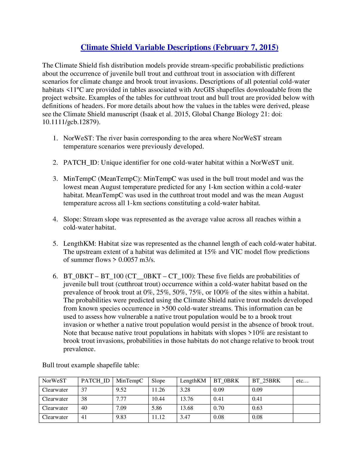 https://research.fs.usda.gov/sites/default/files/2023-06/rmrs-climateshieldshapefilevariabledescriptionsmetadata.pdfFile Type: pdf
File Size: 102KB -
 https://research.fs.usda.gov/sites/default/files/2025-04/rmrs-ucy_1980scutthroattroutbk0.compressed.pdfFile Type: pdf
File Size: 6.45MB
Related Links
- Cold Water Can be Used as a Climate Shield to Protect Native Aquatic Species
- Climate Report Says Healthy Rivers Are Critical for Idaho Native Trout
- Idaho Mountain Express - Report states need to protect rivers
- Jackson Hole News & Guide - Trout could stay cool as the Hole heats up
- High Country News - How to shelter mountain streams in a changing world
- Thermal envelopes and climate change - The Climate CIRCulator
Publications
- Sarah J. Hines, Daniel J. Isaak, Charlie H. Luce, Michael K. Young. 2014. Climate change, crowd-sourcing, and conserving aquatic biotas in the Rocky Mountains this century
- Daniel J. Isaak, Michael K. Young. 2017. Delineating climate refugia for native aquatic species with big crowd-sourced databases
- Daniel J. Isaak, Michael K. Young, David E. Nagel, Dona Horan, Matthew C. Groce. 2015. The cold-water climate shield: Delineating refugia for preserving salmonid fishes through the 21st century
- Daniel J. Isaak, Michael K. Young, David E. Nagel, Dona Horan. 2014. Cold water as a climate shield to preserve native trout through the 21st Century
- Daniel J. Isaak, Michael K. Young, Charlie H. Luce, Steven W. Hostetler, Seth J. Wenger, Erin E. Peterson, Jay M. Ver Hoef, Matthew C. Groce, Dona Horan, David E. Nagel. 2016. Slow climate velocities of mountain streams portend their role as refugia for cold-water biodiversity
- Daniel J. Isaak, Michael K. Young, Dona Horan, David E. Nagel, Michael K. Schwartz, Kevin S. McKelvey. 2022. Do metapopulations and management matter for relict headwater bull trout populations in a warming climate?
- Daniel J. Isaak, Seth J. Wenger, Michael K. Young. 2017. Big biology meets microclimatology: Defining thermal niches of ectotherms at landscape scales for conservation planning
- Michael K. Young, Daniel J. Isaak, Kevin S. McKelvey, Taylor M. Wilcox, Matthew R. Campbell, Matthew P. Corsi, Dona Horan, Michael K. Schwartz. 2017. Ecological segregation moderates a climactic conclusion to trout hybridization
- Michael K. Young, Daniel J. Isaak, Kevin S. McKelvey, Taylor M. Wilcox, Daniel M. Bingham, Kristine L. Pilgrim, Kellie Carim, Matthew R. Campbell, Matthew P. Corsi, Dona Horan, David E. Nagel, Michael K. Schwartz. 2016. Climate, demography, and zoogeography predict introgression thresholds in salmonid hybrid zones in Rocky Mountain streams
- Taylor M. Wilcox, Michael K. Young, Kevin S. McKelvey, Daniel J. Isaak, Dona Horan, Michael K. Schwartz. 2018. Fine-scale environmental DNA sampling reveals climate-mediated interactions between native and invasive trout species
- Kellie Carim, Kevin S. McKelvey, Michael K. Young, Taylor Wilcox, Michael K. Schwartz. 2016. A protocol for collecting environmental DNA samples from streams
- Lisa A. Eby, Olga Helmy, Lisa M. Holsinger, Michael K. Young. 2014. Evidence of climate-induced range contractions in bull trout Salvelinus confluentus in a Rocky Mountain watershed, U.S.A.
- Daniel J. Isaak, Bruce Rieman, Dona Horan. 2009. A watershed-scale monitoring protocol for bull trout
- Kevin S. McKelvey, Michael K. Young, W. L. Knotek, Kellie Carim, T. M. Wilcox, T. M. Padgett-Stewart, Michael K. Schwartz. 2016. Sampling large geographic areas for rare species using environmental DNA: A study of bull trout Salvelinus confluentus occupancy in western Montana
- James T. Peterson, Jason Dunham. 2003. Combining inferences from models of capture efficiency, detectability, and suitable habitat to classify landscapes for conservation of threatened bull trout
- Taylor M. Wilcox, Kellie Carim, Kevin S. McKelvey, Michael K. Young, Michael K. Schwartz. 2015. The dual challenges of generality and specificity when developing environmental DNA markers for species and subspecies of Oncorhynchus
- Taylor M. Wilcox, Kevin S. McKelvey, Michael K. Young, Adam J. Sepulveda, Bradley B. Shepard, Stephen F. Jane, Andrew R. Whiteley, Winsor H. Lowe, Michael K. Schwartz. 2016. Understanding environmental DNA detection probabilities: A case study using a stream-dwelling char Salvelinus fontinalis
- Taylor M. Wilcox, Kevin S. McKelvey, Michael K. Young, Stephen F. Jane, Winsor H. Lowe, Andrew R. Whiteley, Michael K. Schwartz. 2013. Robust detection of rare species using environmental DNA: The importance of primer specificity
- Taylor M. Wilcox, Michael K. Schwartz, Kevin S. McKelvey, Michael K. Young, Winsor H. Lowe. 2014. A blocking primer increases specificity in environmental DNA detection of bull trout (Salvelinus confluentus)
- Joseph R. Benjamin. 2006. Invasion by nonnative brook trout in Panther Creek, Idaho: Roles of habitat quality, connectivity, and biotic resistance
- Jason B. Dunham, Amanda E. Rosenberger, Charlie H. Luce, Bruce E. Rieman. 2007. Influences of wildfire and channel reorganization on spatial and temporal variation in stream temperature and the distribution of fish and amphibians
- Michael K. Young, Kevin S. McKelvey, Kristine L. Pilgrim, Michael K. Schwartz. 2013. DNA barcoding at riverscape scales: Assessing biodiversity among fishes of the genus Cottus (Teleostei) in northern Rocky Mountain streams
- Seth J. Wenger, Daniel J. Isaak, Jason B. Dunham, Kurt D. Fausch, Charlie H. Luce, Helen M. Neville, Bruce E. Rieman, Michael K. Young, David E. Nagel, Dona Horan, Gwynne L. Chandler. 2011. Role of climate and invasive species in structuring trout distributions in the interior Columbia River Basin, USA
- Bruce E. Rieman, James T. Peterson, Deborah L. Myers. 2006. Have brook trout (Salvelinus fontinalis) displaced bull trout (Salvelinus confluentus) along longitudinal gradients in central Idaho streams?
- Bruce E. Rieman, Daniel J. Isaak, Susan B. Adams, Dona Horan, David E. Nagel, Charlie H. Luce, Deborah Myers. 2007. Anticipated climate warming effects on bull trout habitats and populations across the interior Columbia River basin
- Douglas P. Peterson, Bruce E. Rieman, Dona Horan, Michael K. Young. 2014. Patch size but not short-term isolation influences occurrence of westslope cutthroat trout above human-made barriers
- Daniel J. Isaak, Charlie H. Luce, Bruce E. Rieman, David E. Nagel, Erin E. Peterson, Dona Horan, Sharon L. Payne, Gwynne L. Chandler. 2010. Effects of climate change and wildfire on stream temperatures and salmonid thermal habitat in a mountain river network
- Daniel J. Isaak, Wayne A. Hubert. 2004. Nonlinear response of trout abundance to summer stream temperatures across a thermally diverse montane landscape
External Publications
-
United States Department of Agriculture Blog - Cold Water Can be Used as a Climate Shield to Protect Native Aquatic Species
-
Sampling effort to minimize false absences for juvenile Cutthroat Trout or Bull Trout in cold-water habitats. Appendix 2 from Isaak, D., M. Young, D. Nagel, D. Horan, and M. Groce. 2015. The cold-water climate shield: Delineating refugia for preserving native trout through the 21st Century. Global Change Biology 21 doi:10.1111/gcb.12879.
-
Al-Chokhachy R, Budy P. (2008) Demographic characteristics, population structure, and vital rates of a fluvial population of bull trout in Oregon. Transactions of the American Fisheries Society 137:1709–1722.
-
Allen MB, Connolly PJ, Mesa MG et al. (2010) Distribution and movement of Bull Trout in the upper Jarbidge River watershed, Nevada. U.S. Geological Survey, Open-File Report 2010-1033.
-
Buchanan, D., M.L. Hanson, and R.M. Hooton. 1997. Oregon's bull trout, distribution, life history, limiting factors, management considerations, and status. Oregon Department of Fish and Wildlife. Technical Report to Bonneville Power Administration, Contract No. 1994BI34342, Project No. 199505400, (BPA Report DOE/BP-34342-5).
-
Dunham JB, Rieman BE. 1999. Metapopulation structure of bull trout: Influences of physical, biotic, and geometrical landscape characteristics. Ecological Applications 9:642–655.
-
Gamett BL (1999) The history and status of fishes in the Little Lost River Drainage, Idaho. Department of Agriculture, U.S. Forest Service, South Zone Fish Program Report, Salmon-Challis National Forest.
-
Howell, P.J. 2018. Changes in native bull trout and non‐native brook trout distributions in the upper Powder River basin after 20 years, relationships to water temperature and implications of climate change. Ecology of Freshwater Fish 27:710–719.
-
Howell, P.J., P. Sankovich, S. Gunckel, and C. Allen. 2018. A demographic monitoring strategy for Bull Trout core areas in northeastern Oregon and portions of southeastern Washington. U.S. Fish and Wildlife Service report. Portland, OR. 92 pages.
-
Rieman BE, McIntyre JD (1995) Occurrence of bull trout in naturally fragmented habitat patches of varied size. Transactions of the American Fisheries Society 124:285–296.
-
Shepard BB, May BE, Urie W (2005) Status and conservation of westslope cutthroat trout within the western United States. North American Journal of Fisheries Management 25:1426–1440.
-
Young, M.K., D.J. Isaak, K. McKelvey, M. Schwartz, K. Carim, W. Fredenberg, T. Wilcox, T. Franklin, G. Chandler, D. Nagel, S. Parkes-Payne, D. Horan, and S. Wollrab. 2017. Species occurrence data from the Rangewide Bull Trout eDNA Project. U.S. Forest Service Research Data Archive, Fort Collins, Colorado. Available: https://doi.org/10.2737/rds-2017-0038.