


Co-producing Landscape Scale Vulnerability Assessments: Southern Rockies Landscape Conservation Cooperative
Successful management of natural and cultural resources needs to account for increasing stress due to climate change, wildfire, and anthropogenic disturbance and requires collaborative processes to identify effective strategies at landscape scales. Recognizing this need, the SRLCC is implementing a landscape conservation design framework to develop data and tools for use during land management planning, with relevance to multiple stakeholder groups. Rocky Mountain Research Station (RMRS) scientists have partnered with the SRLCC to provide expertise and analytical data products to use towards this effort.
RMRS joined with the SRLCC to develop science and tools that address partner identified needs for management at the landscape scale. As part of this effort, adaptation forums were held to deliver and develop relevant science and decision support tools for practitioners based on previous and ongoing SRLCC projects. In addition, the SRLCC solicited feedback from forum participants on pressing needs and questions related to the management of locally significant resources. Equipped with this information, RMRS developed spatially explicit vulnerability assessments and associated data products for select conservation targets to assist landscape planning efforts within two geographic focus areas.
Activities

- This project produced 4 vulnerability assessment reports covering 5 focal areas: Coldwater fish and riparian corridors, sagebrush ecosystems, pinyon-juniper ecosystems and elk/mule deer.
- Products were developed with feedback by local land managers gathered through a series of adaptation forums and results communicated through two webinars series and 20 in-person presentations given at adaptation forums, SRLCC science committee meetings, and regional workshops and meetings.
- Assessments resulted in 25 maps for each focal area and over 60 datasets representing indicators of exposure, sensitivity and adaptive capacity. These data can be used to generate additional assessments for other targets in these areas or be modified to create assessments tailored to specific manager concerns or needs.
- The framework developed guides the integration of diverse data in such a way that to address multiple user needs regarding threats arising from climate change, land use trends, and landscape characteristics.
Adaptation Forums were held for each landscape to identify the issues and resources most relevant to local land managers. The first round, held in 2016, was facilitated by the Colorado Natural Heritage Program. The purpose of these forums was to identify targets of importance and the final report can be found here:
- 2016 Adaptation Forum workshop (PDF - 691 kb)
The second set, held in 2017, were facilitated by SRLCC and RMRS. These forums were preceded by a webinar series that presented preliminary results of vulnerability assessments and were designed to get feedback from participants to customize the assessment products. In addition, presentations and activities introduced the process for developing adaptation strategies based on assessment findings. See the final report here:
- 2017 Adaptation Forum workshop (PDF - 1.05 MB)
Prior to the second adaptation forum workshop, preliminary assessment results were presented in a series of webinars. Links to the webinar recordings are available below:
Final reports and spatial data for the assessments can be found here:
Or PDFs of the final reports can also be found here:
- Coldwater fish/Riparian corridors (PDF - 7.28 MB)
- Coldwater fish appendix 1 (PDF - 5.26 MB)
- Coldwater fish appendix 2 (PDF - 562 kb)
- Coldwater fish appendix 3 (PDF - 796 kb)
- Sagebrush (PDF - 2.31 MB)
- Pinyon-juniper (PDF - 4.34 MB)
- Elk/Mule deer (PDF - 2.61 MB)
Interactive PDFs are also available for each assessment with the exception of elk and mule deer.
- Coldwater fish (PDF - 44.38 MB)
- Riparian corridors (PDF - 44.44 MB)
- Sagebrush (PDF - 9.11 MB)
- Pinyon-Juniper (PDF - 6.97 MB)
Key Personnel
Principal Investigator
-
Person

Megan M. Friggens, PhD
Research Ecologisthttps://research.fs.usda.gov/about/people/megan.friggens
Forest Service Partners
-
Person

Deborah M. Finch, PhD
Scientist Emeritushttps://research.fs.usda.gov/about/people/deborah.m.finch -
Person

David L. Hawksworth
Wildlife Biological Technicianhttps://research.fs.usda.gov/about/people/david.l.hawksworth -
Person

D. Max Smith
Ecologist (Cooperator/Contractor)https://research.fs.usda.gov/about/people/david.smith3
Collaborators
John Rice, SRLCC Science Coordinator, Bureau of Reclamation
Kevin Johnson, SRLCC Coordinator, Fish and Wildlife Service
Mary Williams, Nez Perce Tribe
Tzeidle Wasserman, Northern Arizona University
Stephanie Mueller, Northern Arizona University
Colorado Natural Heritage Program
Documents
-
 https://research.fs.usda.gov/sites/default/files/2023-04/rmrs-2017_adaptation_forum_workshop_report.pdfFile Type: pdf
File Size: 1.10MB -
 https://research.fs.usda.gov/sites/default/files/2023-04/rmrs-2016_adaptation_forum_workshops_finalreport.pdfFile Type: pdf
File Size: 708KB -
 https://research.fs.usda.gov/sites/default/files/2023-04/rmrs-final_lcc_assessments_013018_webinar.pdfFile Type: pdf
File Size: 5.66MB -
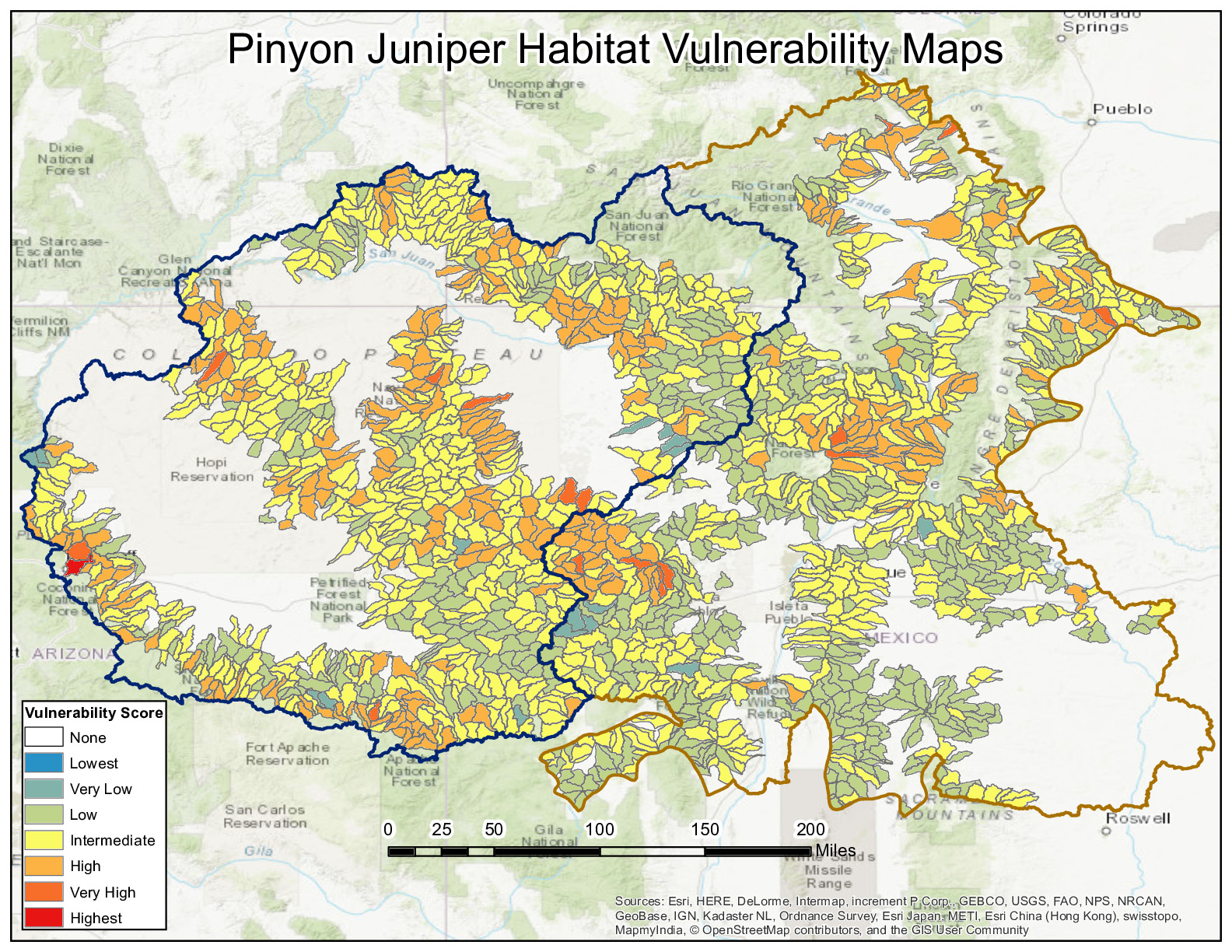 https://research.fs.usda.gov/sites/default/files/2023-04/rmrs-pj_interactive.pdfFile Type: pdf
File Size: 7.30MB -
 https://research.fs.usda.gov/sites/default/files/2023-04/rmrs-sagebrush_intpdf.pdfFile Type: pdf
File Size: 9.55MB -
 https://research.fs.usda.gov/sites/default/files/2023-04/rmrs-riparian_interactive.pdfFile Type: pdf
File Size: 46.60MB -
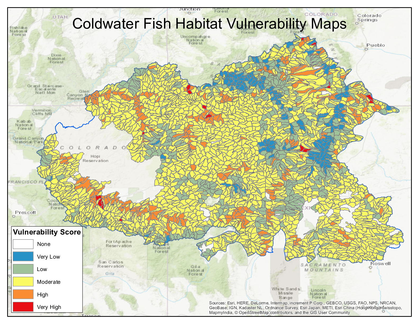 https://research.fs.usda.gov/sites/default/files/2023-04/rmrs-coldwaterfish_interactive.pdfFile Type: pdf
File Size: 46.53MB -
 https://research.fs.usda.gov/sites/default/files/2023-04/rmrs-final_aquatic_assessment_report_1.pdfFile Type: pdf
File Size: 7.64MB -
 https://research.fs.usda.gov/sites/default/files/2023-04/rmrs-final_aquatic_assessment_report_appendix_2.pdfFile Type: pdf
File Size: 575KB -
 https://research.fs.usda.gov/sites/default/files/2023-04/rmrs-final_aquatic_assessment_report_appendix_3.pdfFile Type: pdf
File Size: 815KB -
 https://research.fs.usda.gov/sites/default/files/2023-04/rmrs-final_aquatic_assessment_report.pdfFile Type: pdf
File Size: 7.64MB -
 https://research.fs.usda.gov/sites/default/files/2023-04/rmrs-sagebrush_vulnerability_assessment_srlcc_final.pdfFile Type: pdf
File Size: 2.42MB -
 https://research.fs.usda.gov/sites/default/files/2023-04/rmrs-elk_and_mule_deer_vulnerability_assessment_srlcc_final.pdfFile Type: pdf
File Size: 2.74MB -
 https://research.fs.usda.gov/sites/default/files/2023-04/rmrs-pinyon_juniper_assessment_final.pdfFile Type: pdf
File Size: 4.56MB -
 https://research.fs.usda.gov/sites/default/files/2023-04/rmrs-final_aquatic_assessment_report_appendix_1.pdfFile Type: pdf
File Size: 5.52MB